This section draws heavily on the pioneering work by Markus Hauser in his Pamir Archive and, with his permission, on a short brochure published in 2000 in only 30 copies on which he worked with Mira Alekseyevna Bubnova of the Tajik Academy of Sciences (A. Donish Institute of History, Archaeology and Ethnography).
The University of Central Asia (UCA) has just published a comprehensive work by Mira Alekseyevna Bubnova on the archaeological sites of the Western Pamirs, entitled An Archaeological Map of Gorno-Badakhshan Autonomous Oblast: the Western Pamirs. It is available from the Khorog campus of UCA, and from the Institute of History, Archaeology and Ethnography of the Academy of Sciences of Tajikistan or the Museum of Antiquities in Dushanbe. See here.
The first traces of civilisation in the Pamirs go back more than 20,000 years. Some 50 human settlements from the Stone Age have been found in the Eastern Pamir. Cave paintings from this period can be seen near the village of Djarty-Gumbez, 40km South of Murghab, just off the main road to Khorog.
A ritual fire-worshipping site can be found at Lake Yashilkul on the estuary of the Major Marjanai river near the village of Bulumkul. Another fire temple can be seen in the village of Bogiv, 9km from the regional centre, Khorog. (photo Peter Burgess)

There are solar calendars in the Shuraly valley in upper Bartang, near Goudara (Kokjar pass), and in Yamg village, 80 km from Ishkashim.

Stone used as a solar calendar by Sufi Muboraki Vakhoni (1839-1930), Yamg in Ishkashim district.

Caravanserai on the Alichur river
Photo Surat Toimastov
There is a Buddhist stupa in the village of Vrang – 87km from Ishkashim.

Many petroglyphs are found near the village of Lyangar (120km from Ishkashim).
The Wakhan (Ishkashim district) was one of the main branches of the Silk Road (also known as the Buddhist Route). Here there are many traces of the great castles that guarded the route, offered hospitality and exacted tribute – most of them built during the Kushan period (second century BC to third century AD).
There are several castle ruins near the centre of Ishkashim, on the banks of the Pyandj.

In the village of Namadgut (17km from Ishkashim), there is a large fairly well-preserved castle known as Khakhka dating from the fourth century BC (photo Surat Toimastov)


The imposing fortress known as ‘Zamr-i-atish-parast’ (‘Fortress of fire worshippers’) above the village of Yamchun (72km from Ishkashim). The earliest part of the construction dates from the third century BCE
In the village of Zong (113km from Ishkashim) there are the ruins of a number of castles, including Vishimkala (photo Surat Toimastov)

Umbuq castle near Vrang
There are many interesting archaeological sites also in the Shokhdara valley (Roshtkala district). The remains of castles can be seen in:
• Roshtkala (district centre)
• Shashbuvad village (118km from Khorog) and
• the valley of the Djavshangoz river

Derudj castle (5th to 7th century AD) – near Djavshangoz
Other fortress-type buildings served to protect the extended families of farmers and herdsmen (here in the village of Shashbuvad in Upper Roshtkala).
Bazardara mining settlement
There are the remains of a medieval mining settlement (copper, tin, silver) in Bazardara in Murghab district between the Alichur and Murghab rivers – see here.
Another fire temple can be seen in the village of Bogiv, 9km from the regional centre, Khorog. (photo Peter Burgess).

Stone used as a solar calendar by Sufi Muboraki Vakhoni (1839-1930), Yamg in Ishkashim district.

Caravanserai on the Alichur river Photo Surat Toimastov
There is a Buddhist stupa in the village of Vrang – 87km from Ishkashim.

There are solar calendars in the Shuraly valley in upper Bartang, near Goudara (Kokjar pass), and in Yamg village, 80 km from Ishkashim.

Many petroglyphs are found near the village of Lyangar (120km from Ishkashim).
The Wakhan (Ishkashim district) was one of the main branches of the Silk Road (also known as the Buddhist Route). Here there are many traces of the great castles that guarded the route, offered hospitality and exacted tribute – most of them built during the Kushan period (second century BC to third century AD).
There are several castle ruins near the centre of Ishkashim, on the banks of the Pyandj.

In the village of Namadgut (17km from Ishkashim), there is a large fairly well-preserved castle known as Khakhka dating from the fourth century BC (photo Surat Toimastov)
In the village of Zong (113km from Ishkashim) there are the ruins of a number of castles, including Vishimkala (photo Surat Toimastov)

Umbuq castle near Vrang


The imposing fortress known as ‘Zamr-i-atish-parast’ (‘Fortress of fire worshippers’) above the village of Yamchun (72km from Ishkashim). The earliest part of the construction dates from the third century BCE.
Many petroglyphs are found near the village of Lyangar (120km from Ishkashim).
The Wakhan (Ishkashim district) was one of the main branches of the Silk Road (also known as the Buddhist Route). Here there are many traces of the great castles that guarded the route, offered hospitality and exacted tribute – most of them built during the Kushan period (second century BC to third century AD).
There are several castle ruins near the centre of Ishkashim, on the banks of the Pyandj.
There are many interesting archaeological sites also in the Shokhdara valley (Roshtkala district). The remains of castles can be seen in:
• Roshtkala (district centre)
• Shashbuvad village (118km from Khorog) and
• the valley of the Djavshangoz river

Derudj castle (5th to 7th century AD) – near Djavshangoz
Other fortress-type buildings served to protect the extended families of farmers and herdsmen (here in the village of Shashbuvad in Upper Roshtkala).

Bazardara mining settlement
There are the remains of a medieval mining settlement (copper, tin, silver) in Bazardara in Murghab district between the Alichur and Murghab rivers – see here.
Petroglyphs and pictographs
Gorno-Badakhshan has more than 10,000 petroglyphs and pictographs, several dating from the late paleolithic period
(8,000 BCE). Most are (fortunately for their preservation) some distance from the main roads and many villagers are unaware of their presence. (The pictures below illustrate what can happen when unthinking local people deface a rock exhibiting petroglyphs.)
Until funds are available for recording, analysing and dating
(and, not least, protecting) them, the photographs below
(kindly provided by Markus Hauser and Vatani Alidodov) are intended only as a first indicator of this cultural and historical wealth and as an incentive to the serious traveller in the Pamirs (are there any others just yet?) to explore further.
A petroglyph is an image engraved on a rock. A pictograph is an image painted on a rock.
Links:
https://depts.washington.edu/silkroad/archaeology/mongolia/


Petroglyphs in Langar (Ishkashim district)
Pictographs in Shakhty cave (Murghab district)

Reproduction of petroglyphs in Akjilga (Murghab district)

Sufi poem

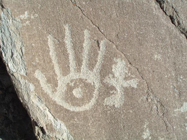
Hand of Ali (5 principles of Islam) and rubob in anthropomorphic shape

Hand, rubob, rider and ibex

Anthropomorphic figures in the shape of a rubob

Anthropomorphic figures with dogs (?)

Rider with sword (?)

Hands and rubob

Ibex

Rubob

Sufi poem

Zulficar, sword of Ali

Sufi poem

Ibex